
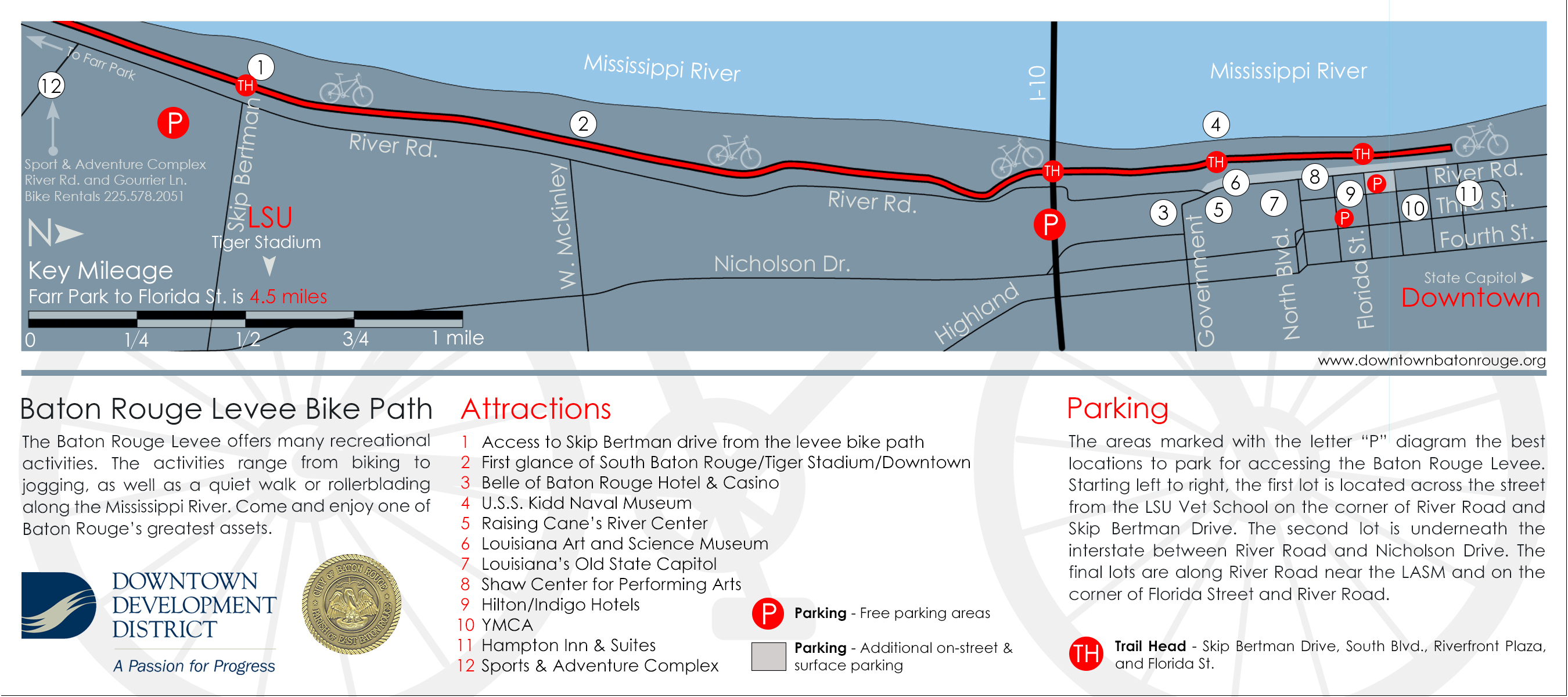
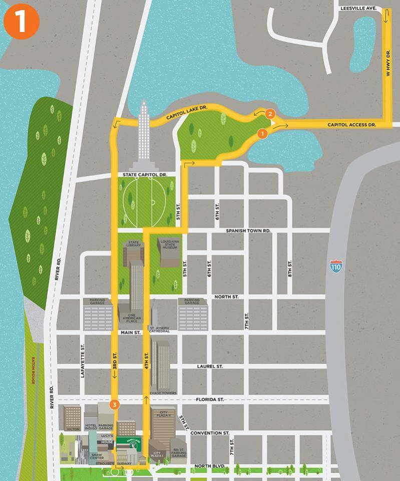
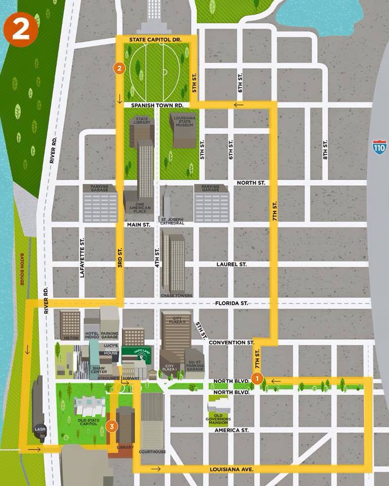
Mississippi River Levee Trail
A 13 mile stretch of the levee bike path extends from Downtown south to LSU, and continues to L'Auberge Casino at the southern end of the parish. The 15 foot wide path includes separate lanes for bicycles and walkers/joggers as well as lighting, seating and water fountains.
The Mississippi River Levee Trail offers many recreational activities. The activities range from biking to jogging, as well as, a quiet walk or rollerblading along the Mississippi River. People looking for a quick, downtown calorie-burning exercise can follow the .5 mile and 1.5 mile Levee Loop Paths on the map below. Come enjoy one of Baton Rouge’s greatest assets.

Downtown Greenway
The Downtown Greenway is a 2.75-mile interconnected network of bike/pedestrian pathways connecting Baton Rouge’s public parks and recreational facilities, inner city communities, and cultural attractions through the use of greenways, or linear parks. The multi-phased, alternative transportation project now has approximately 1.75 miles completed and strengthens our community’s connectivity and social cohesion, promoting revitalization and adding economic value. The Downtown Development District is the lead agency responsible for administering the Downtown Greenway project, in partnership with the East Baton Rouge City-Parish.
Approximately $3 million dollars has been acquired from national, state, and local grant resources to plan and/or construct the completed portions of the Downtown Greenway. Completed portions of the Downtown Greenway include sections at Expressway Park and Myrtle Street, T.J. Jemison and East Boulevard, and North Boulevard, totaling approximately 1.75 miles. The Downtown Greenway connects to the 13.1 mile Mississippi Levee Trail and the 4 mile bicycle lanes on Government Street.

American Heart Association Walking Paths
The walking paths, featuring three distances of one mile, two miles and three miles, is a step toward heart disease prevention and reducing heart disease death in the capital area. Heart disease is the No. 1 killer in Louisiana, according to the American Heart Association. The walking paths are sponsored by Albemarle Foundation, Amedysis and Milton J. Womack.
The American Heart Association’s designated Walking Path program provides safe and accessible walking paths that give communities a resource that can be used to increase heart health.

Happy's Running Club
Happy’s Running Club is a combination of serious and recreational runners and a great resource for anyone looking for training partners for any running distance. Organized runs are scheduled for every Tuesday at 6:00 p.m. (run begins at 6:15 sharp) – Starting at Happy's Irish Pub on Third Street downtown. The runs rotate between 5 routes in order to keep things fresh. Maps of the routes (located below) are provided before the weekly run.
The club was started in 2008 by Scott Higgins and Michael Lang and has grown to 1000 members with a weekly average of 300 runners each week. The sole philosophy of the club is also their motto: “Run… drink… and be HAPPY!”
Running Club Facebook Page
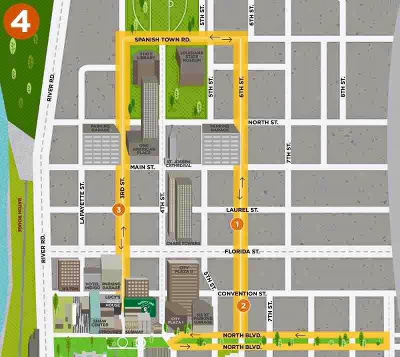
Route 1
Route 2
Route 3
Route 4
Route 5

YMCA Running Path
The YMCA running paths feature one, two, and three mile distances beginning at the downtown location, Charles W. Lamar Jr branch. The branch is located near the State office buildings and IBM offices at 521 Third Street.
The Charles W. Lamar Jr. YMCA is located in Downtown Baton Rouge, and has been serving the area since 2001.